Unmanned Aerial Systems (UAS)
With our fleet of unmanned aerial systems (UAS), Michael Baker provides innovative, cost-effective approaches that compliment traditional manned-aircraft acquisitions or ground-based surveys. Our team of licensed Part 107 pilots are located across the U.S. to provide national coverage with local response. To serve your needs, we have rapid deployment abilities for accelerated project schedules. With a sizable number of professional-grade UAS vehicles, multiple aircraft can be operated simultaneously at an individual location to provide same-time, precise, aerial solutions for large areas.
Our fleet of UAS includes a mix of fixed-wing and Vertical Takeoff and Landing (VTOL) aircraft that facilitate the rapid capture of high-resolution color imagery, thermal Forward Looking Infrared (FLIR) and Color Infrared (CIR) imagery. As licensed engineers and surveyors, we also create orthophotos and 3D models to support engineering projects.
We are at the forefront of adopting and incorporating the latest UAS technologies and best practices to provide creative technical solutions for our clients. We offer UAS collections and derived products for missions supporting:
- Emergency Response
- Law Enforcement
- Aerial Inspection and Mapping
- Agriculture and Wildlife
- Media Relations and Marketing Agencies
We recently collaborated with Intel and the Kentucky Transportation Cabinet to use drone technology to help inspect and analyze the Daniel Carter Beard Bridge, an eight-lane interstate that crosses the Ohio River. By leveraging the latest drone technology, the bridge – which carries nearly 100,000 vehicles daily – remained open and fully functional during inspection.
 Technology Spotlight
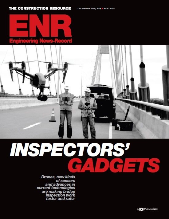 Our experts routinely leverage drone technology and rope access to enhance the safety and efficiency of bridge inspections. Our work was featured in Engineering News-Record (ENR) magazine with insights from Scott Roux, National Bridge Practice Lead, and Paul McGuinness, Bridge Inspection Lead.
Click the ENR cover to read more.
Light Detection and Ranging (LiDAR)
Few technologies have evolved as quickly or have been adopted as broadly as Light Detection and Ranging (LiDAR). As an early adopter, Michael Baker uses LiDAR for nearly all engineering, surveying and mapping, architectural and visualization applications.
We are one of the foremost experts in the application of LiDAR to collect information on roadways, airports, utilities, rail and transit systems and for smart vehicle technology. We are currently applying our knowledge to lead the implementation of connected vehicles for the deployment and testing of smart vehicle technology in various developed environments and roadways. We use LiDAR to support development of a smart transportation network that’s safer, more efficient, less expensive and largely automated.
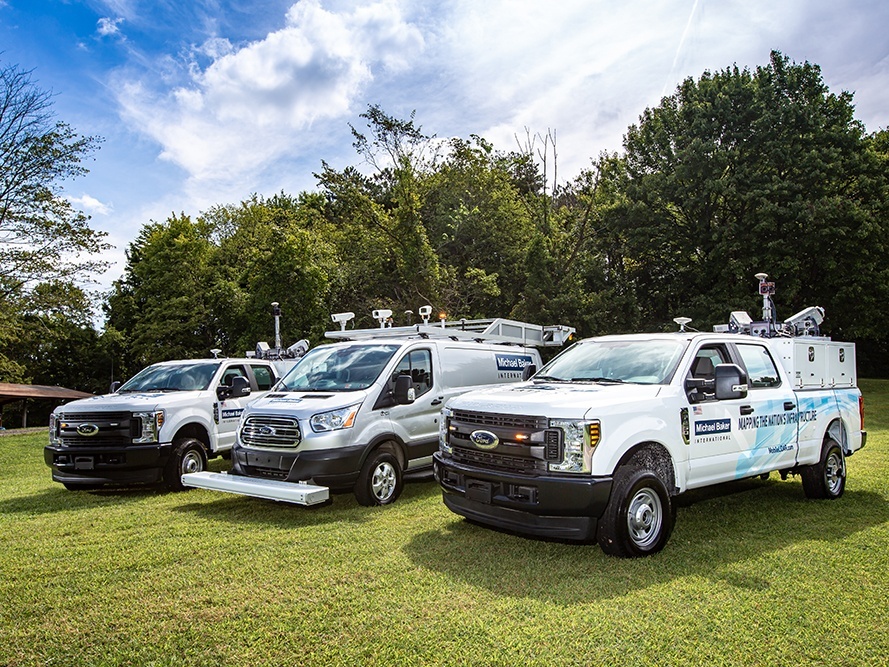
- Mobile LiDAR: Our fleet of mobile LiDAR systems deliver highly precise and efficient survey and mapping solution for cataloging information on our nation’s critical infrastructure and environment.
- Aerial LiDAR: Michael Baker plans and acquires large-area aerial LiDAR through a network of operators with high or low altitude manned-aircraft. We process the resulting point cloud to create digital models representing ground surfaces.
- UAS LiDAR: We collect and process UAS-derived LiDAR which can produce extraordinarily dense point clouds, as compared to manned-aircraft systems and conventional aerial LiDAR. We also provide Virtual Reality (VR) and Augmented Reality (AR) capabilities using UAS LiDAR point clouds and UAS-collected imagery data.
- Static Scanning LiDAR: We own and operate a variety of static scanning stations to collect high-resolution LiDAR data. These workhorse systems collect very precise and dense point clouds to support many engineering and architecture needs for both indoor and outdoor spaces.
- Robotic and Wearable LiDAR: The portability of compact, low-power consumption LiDAR systems allows autonomous terrestrial or marine survey robots to operate in confined spaces and dangerous or harsh environments. We provide unique, customizable configurations of LiDAR equipment for autonomous robots or wearable systems.
Pavement Technologies
Michael Baker provides a full range of pavement engineering and management services using technology-based approaches for complete pavement data collection, assessment, design and implementation of pavement management systems.
- Systems and Capabilities: Our data collection vehicles are equipped with sophisticated, sensor-based laser crack measuring systems (LCMS) providing precise positioning and measurement capabilities for scanning a pavement surface.
- Certified Technology: We secured a National Center of Asphalt Technology (NCAT) certification for our LCMS technology, which was the first 3D scanning system to pass the nationally recognized and rigorous data evaluation test.
- Quality Assurance Technology: We developed quality control applications to validate the results of the pavement analysis resulting from our automated data extraction. We compare automated extractions to collected downward facing imagery to ensure our machine learning algorithms have appropriately classified distress types and their values.
- Pavement Condition Index (PCI) and Visualization: Pavement distress identification and categorization are compiled and compared using the PAVER™ software. Scenarios are used to identify, quantify and provide cost estimates for preventative maintenance and construction improvement projects.
- Additional Technologies for Pavement Design and Management:
- Ground Penetrating Radar (GPR): We employ GPR to detect voids below the pavement and determine deteriorations of bridge decks with or without an asphalt overlay. We do this at highway speed without interrupting normal traffic patterns.
- Falling Weight Deflectometer (FWD) Testing: Recommended by AASHTO, we use FWD testing for pavement evaluation and to determine the structural strength of the pavement and subgrade, pavement layer properties, concrete joint performance, voids under joints and estimation of remaining service life.
- Pavement Life Cycle Cost Analysis (LCCA): We provide pavement LCCA consultant services to transportation agencies supporting long term budgeting and planning alternatives.
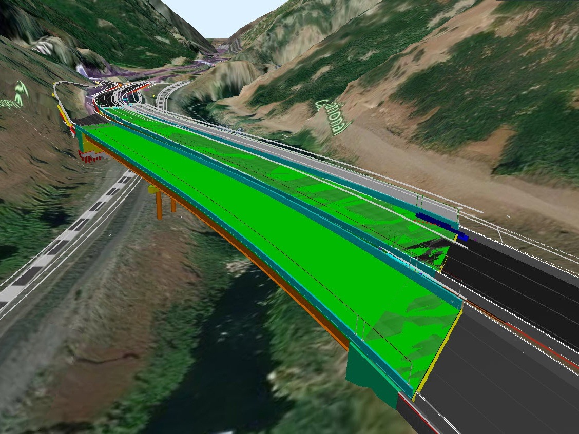
Engineered Models
Engineered modeling, often combined with the related topics of Building Information Modeling (BIM) and Digital Delivery, is transforming the way we design, build and manage our infrastructure assets. FHWA, AASHTO, contractors, and a growing number of state DOTs widely recognize the benefits of 3D engineered models for delivering and constructing highway transportation projects. The technology is mature and serves as a key element for promoting collaboration and efficiency throughout the asset lifecycle. From engineering-grade visualizations to digital twin asset representations, these models enhance our ability to convey design intent to multiple stakeholders and facilitate automation in the numerous data exchanges required in every project. As an industry leader, Michael Baker is investing in its team to keep pace with the constant evolution of the digital landscape and unlock the largely untapped potential of engineered models for our clients.
Our team of technology experts has provided digital support services for more than 300 projects and are currently leading innovative Pilot Projects for several clients by applying our knowledge and leveraging our experience. Michael Baker develops strategic solutions to address the challenges associated with the adoption of engineered models in the production of integrated and future-ready deliverables.
In addition to traditional 3D engineered models, Michael Baker offers many related services such as:
- Utilization of 4D and 5D modeling for scheduling and pricing
- Custom training courses and materials
- Support for the creation of personalized workspaces and workflows
- Model as the contract document
- Robust QA/QC process for digital deliverables
- Integration of LiDAR and UAS products into federated models
- Model development and review processes and procedures for design and construction planning
- 3D animated and still renderings for public involvement and comment
- Immersive technologies such as augmented reality and virtual reality for inspections and stakeholder engagement