
Michael Baker’s DATAMARK Technologies team provided comprehensive geospatial services for the Alabama Statewide NG9-1-1 GIS Implementation project, transforming emergency response capabilities across all 67 counties. The team unified and standardized GIS data for the Alabama Next Generation Emergency Network, ensuring that emergency calls were routed with precision based on caller location rather than legacy boundaries. This statewide initiative elevated geospatial data quality and interoperability for more than 100 Public Safety Answering Points (PSAP) and 85 emergency communication districts.
The DATAMARK Technologies team addressed the challenge of integrating diverse datasets from agencies with varying levels of GIS maturity and resources. They led a multi-phase strategy, coordinating technical efforts and fostering collaboration among local stakeholders. The team conducted regional training sessions and workflow management courses, empowering local GIS and PSAP leaders to actively contribute to a unified, future-ready geospatial framework.
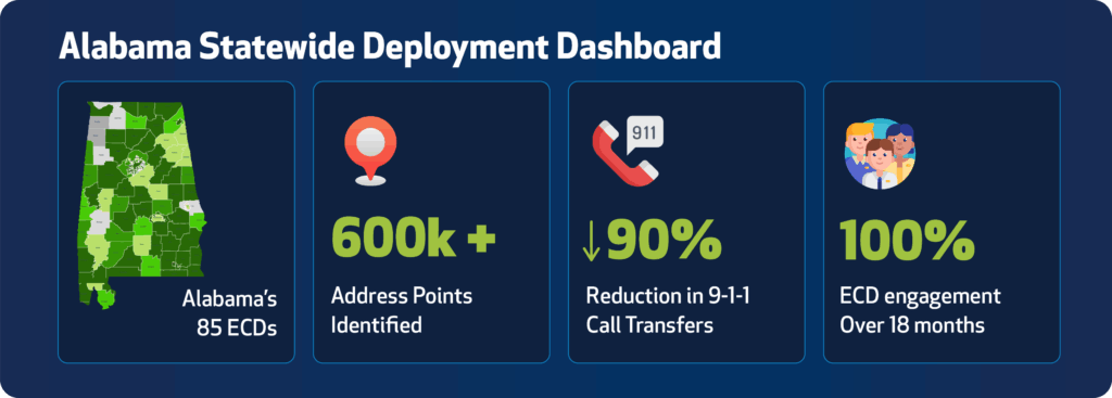
DATAMARK Technologies standardized road centerlines, address points and emergency service boundaries, creating NG9-1-1-compliant datasets that enabled faster and more accurate emergency response. The team facilitated data validation and quality assurance, ensuring that every dataset met rigorous standards for reliability and completeness. By streamlining data exchange and supporting seamless interoperability, Michael Baker helped Alabama set a new benchmark for statewide public safety innovation.
Through strategic coordination, technical expertise and a commitment to excellence, the team delivered a transformative solution that strengthened Alabama’s emergency communications infrastructure and enhanced public safety for millions of residents.